Geotag your photos in Lightroom Classic

A gentleman in tan hat and plaid shirt standing at a busy car boot sale in Bantry with market stalls and shoppers browsing various items spread on tables, County Cork.

Geotagging your photos means adding location data to the image so they can be displayed on a map. Be aware that doing so might reveal sensitive information you’d rather keep secret like your home address.

You can of course remove location data when you export images, like I did with the images in this post.

Anyway, here is how I geotag my photos.

For photos I’ve already taken, I use Google Timeline and export it from my Google account using Google Takeout. You’ll get a rather large “Recent.json” file out of that. To convert that file into the GPX format usable by Lightroom Classic, use this Python script which I’ve already covered in this post.

When I go out with my camera now I use the Anrdoid app, OpenTracks. It’s a free app you can grab from f-droid, but there’s also a paid version on the Google Play Store if you want to support the developer. You can also use GPSLogger, a free app that has the advantage of being able to save your .gpx files to Dropbox or Google Drive.

On iOS, the myTracks app appears to do a similar job but I can’t test it. Please comment if you have tried it or know of decent alternatives.

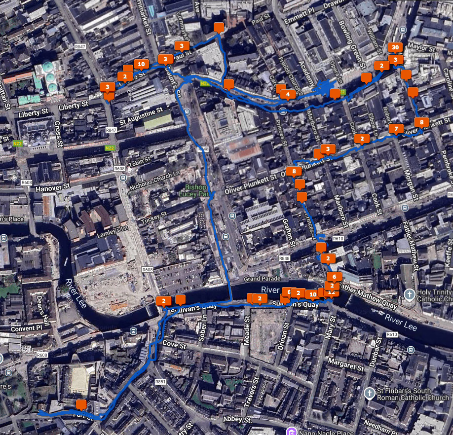
To geotag your photos in Lightroom Classic, the Adobe documentation on the subject is excellent. Once you’ve opened the Map Module and done it once it’s easy to do again. When you geotag your photos, the Map Module will look like this.

A satellite view of Cork City with a blue line showing where I walked and orange squares showing how many photos I took at various locations.

There is also Jeffrey’s “Geoencoding Support” Plugin for Lightroom that I’ve used for years but maybe it’s because of changes to LrC in recent years, it’s gotten really slow for me. I usually use the built in LrC functionality in the Maps module now.

There’s no such thing as a safe tan

The What’s Up Docs podcast from the BBC is an entertaining but factual podcast about health presented by two doctors, Chris and Xand van Tulleken (brothers and twins!) who find out to their dismay that they were wrong about the dangers of getting a nice healthy colour from the sun.

A cat lying on the ground and enjoying the sun.

A tan occurs when UV radiation damages skin cells, causing them to produce more melanin as a protective response. This process involves DNA damage to skin cells, which can accumulate over time and potentially lead to skin cancer.

Sunburn is obviously harmful and painful. Even one blistering sunburn in childhood can double your lifetime risk of melanoma.

It’s a bit late for my Irish readers, as we had cloudless skies and a hot sun last week. Temperatures reached 25C where I was, so I slapped on the factor 50 sunscreen and made sure I was wearing a hat when I was outside. Many years ago, a neighbour died of skin cancer at the age of 52, only a few years older than I am now.

The Met Éireann UV Index page will show you what the UV index in Ireland is. If it’s 3 or over, you should be covering up with clothing or sunscreen. It’s quite alarming that the difference between a clear sky and a cloudy sky is 1-2 or 8-10 on that index.